Torres del Paine
Torres del Paine
Granite massifs, glaciers and turquoise lakes across 1,800 km² in Chilean Patagonia: practical guide to visiting Torres del Paine from Puerto Natales.
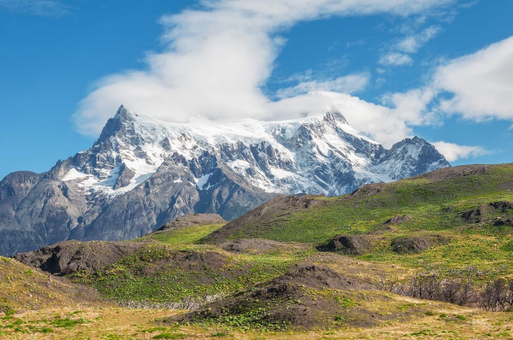
Torres del Paine National Park, in southern Chilean Patagonia, covers more than 1,800 km² of granite massifs, glaciers, turquoise lakes and steppes populated by guanacos. From Puerto Natales, its trails attract hikers and photographers who come to trek the famous W route or the O circuit around the Paine massif.
Why visit Torres del Paine
The park concentrates in a single location most of Patagonia's iconic landscapes: vertical granite towers, active glaciers, lenga forests, glacial lagoons and endemic wildlife. Designated a UNESCO Biosphere Reserve in 1978, it offers itineraries suited to casual walkers and experienced trekkers alike, ranging from a few hours to ten days.
Its position in southern Chili, more than 2,500 km from Santiago, makes it a major stop for those heading to the continent's far south. The park also lends itself to shorter boat excursions, notably to Grey Glacier, or to wildlife observation in the pampa zones.
History and formation of the massif
The Paine massif resulted from tectonic movements that occurred 12 million years ago, which caused a granite batholith covered with dark schists to rise, creating the characteristic colour contrast of the Cuernos del Paine. The Tehuelche Indians, the area's first inhabitants around 12,000 years ago, named the massif Paine, meaning "blue" in their language. Torres, in Spanish, designates the "towers": the three granite formations that dominate the park.
The first Western travel accounts date back to Lady Florence Dixie's expedition in 1879, which helped make the region known in Europe. In 1959, the Parque Nacional de Turismo Lago Grey was created to protect the sector's ecosystems. It was renamed Torres del Paine National Park in 1970, then designated a UNESCO Biosphere Reserve in 1978.
What to see and do
The summits and glaciers
The park is dominated by several peaks: Cerro Paine Grande (3,050 m), the three Torres del Paine (2,250, 2,460 and 2,500 m), Cerro Escudo (2,240 m), Cerro Fortaleza (2,680 m) and the Cuernos del Paine (2,600, 2,400 and 2,200 m). Grey Glacier, an ice tongue from the South Ice Field, descends into Grey Lake where bluish icebergs float. It is accessible on foot from Grey Refuge or by boat from Pudeto.
The lakes and lagoons
The park's coloured waters hold a central place in the landscape: Dickson, Nordenskjöld, Pehoé and Sarmiento lakes, Verde, Azul and Honda lagoons. Lake Pehoé, crossed by catamaran, serves as an access point to the western sector of the W trek.
Wildlife
The park is home to characteristic Patagonian fauna. You can regularly observe guanacos, Andean condors and Andean flamingos. The huemul, an emblematic Andean deer of Chili, and the puma, more elusive, are among the protected species present on the territory.
The W trek and O circuit
The W trek, approximately 75 km long, takes 4 to 7 days and covers the park's three major valleys: Valle de Ascencio (climb towards the base of the Towers), Valle del Francés (facing the Cuernos) and Valle del Glaciar Grey. More demanding, the O circuit traces a complete loop around the massif and generally takes 8 to 10 days, taking the less-frequented northern face. Hikers with limited time opt for day trips, such as the climb to Base Towers or the Cuernos viewpoint.
When to go
The park is open year-round, but conditions vary greatly by season. In the austral summer, from January to March, temperatures can reach 20°C; in winter, between July and September, they can drop to -2°C. Sustained Patagonian winds and humidity significantly lower the perceived temperature in all seasons.
The period from October to March is most favourable: long days of about 16 hours, more moderate rainfall and trails fully open. Late March and early April offer autumn colours on the lenga forests, with already quieter visitor numbers.
How to get there
Puerto Natales serves as the departure base to reach the park. Daily buses connect the town to the Laguna Amarga entrance in 2 to 3 hours, where access tickets are purchased. Two main entry points structure the visit: Las Torres in the east, for the Towers sector and Valle de Ascencio, and the Pudeto ranger station in the west, from where the catamaran departs to the Paine Grande sector.
The nearest airport is in Punta Arenas, connected to Puerto Natales by bus for about 3 hours. A longer option is to board the weekly ferry from Puerto Montt: the crossing takes about 3 days and follows the fjords and canals of southern Chili.
Practical information
- Duration of visit: from one day for a targeted excursion to 4-10 days for the W or O.
- Rates: paid entry at CONAF, with higher rates during high season (October-April) and reduced rates in low season. Online booking recommended.
- Accommodation: refuges, campsites and lodges along the trails; advance booking essential several months ahead for high season.
- Equipment: windproof and waterproof clothing, hiking shoes, warm layers, even in summer.
- Safety: wild camping prohibited, fires strictly forbidden, trails must be respected.
Nearby
To extend your journey through Patagonia and Chili, several sites are worth visiting:
- Beagle Channel, a navigable waterway between the southern fjords.
- El Tatio geysers, in the Atacama Desert to the north.
- La Moneda Palace in Santiago, seat of the Chilean government.
- Mercado Central de Santiago, a historic market dedicated to seafood products.
Frequently asked questions
Frequently asked questions
Plan your trip
Torres del Paine fits into a broader itinerary across Patagonia or the entire country. See our suggestions to organize your trip to Chili and combine the park with other stops based on your duration and interests.
Interested in this visit?
We can include it in your personalised itinerary.