Vallée del Arcoíris
Vallée del Arcoíris
About 60 km from San Pedro de Atacama, the Vallée del Arcoíris combines multicolored mineral landscapes with Atacameño petroglyphs from the Hierbas Buenas site.
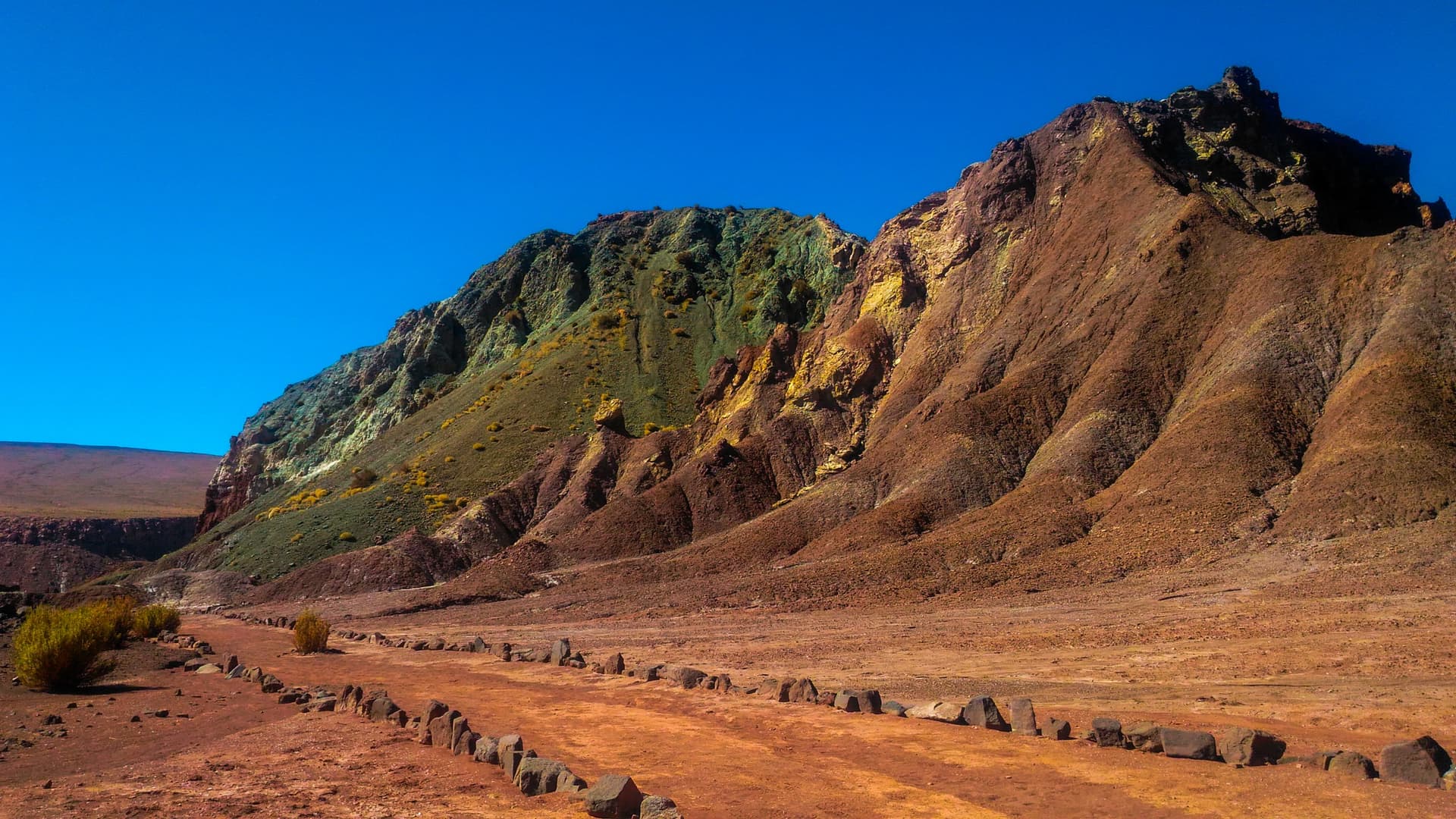
Approximately 60 km northwest of San Pedro de Atacama, the Vallée del Arcoíris displays a remarkable palette of mineral colors across the Atacama Desert. Red cliffs, green summits, white walls: the palette results from singular geology, combined with a remarkable archaeological site, Hierbas Buenas, and its Atacameño petroglyphs.
Why visit the Vallée del Arcoíris
Located at 3,500 meters altitude, the valley serves as a useful acclimatization stop before tackling higher sites like the Tatio geysers or Salar de Tara, both above 4,000 meters. Visitor numbers remain moderate compared to Atacama's main attractions, making it a quieter experience to observe the landscapes and walk among the rock formations.
The appeal is twofold: geological, with colors resulting from the oxidation of minerals present in the rocks (calcite, iron oxides, copper, pyrite), and archaeological, thanks to the Hierbas Buenas site located in immediate proximity.
What to see
The colored formations
The valley takes its name from the multicolored appearance of its relief. The colors come from mineral alteration and vary throughout the day depending on the angle of light. Red cliffs neighbor summits with green, white, or yellow hues. Hikers can follow trails running along the hills to observe the walls from different angles.
For photography, the raking light of early morning and late afternoon accentuates the mineral contrasts.
The Hierbas Buenas archaeological site
Behind the rock formations lies Hierbas Buenas, a site renowned for its petroglyphs carved by the Atacameño people. The walls bear animal representations (llamas, foxes) as well as more singular figures such as two-headed creatures or shamans. The collection testifies to long human presence in the desert and adds cultural dimension to the geological visit.
Practical information
- Altitude: 3,500 m, plan for good hydration.
- Visit duration: allow 2 to 3 hours on site, longer if you combine with Hierbas Buenas.
- Equipment: hiking shoes, sun protection, water, windbreaker. Temperatures rise quickly in the morning.
- Vehicle: 4x4 strongly recommended due to the final track.
- Fee: moderate entrance fee, collected upon arrival at the site.
The site can be visited independently or through an English-speaking agency from San Pedro de Atacama. Agency outings typically include transport, a guide, and access to the petroglyphs.
When to go
The best period runs from October to December: low tourist season, reduced rates, and mild weather conditions. Visitor numbers increase during the Southern Hemisphere winter, in July and August, when the sky remains very dry and bright but nights are cold.
An early departure around 7 a.m. is recommended: the cool morning is more pleasant for walking and most tour operators arrive mid-morning. You thus enjoy the site with few visitors and softer light on the walls.
How to get there
The Vallée del Arcoíris is located approximately 60 km northwest of San Pedro de Atacama. The route is as follows:
- Leave San Pedro via Route 23-CH toward Calama.
- After 35 km of paved road, turn right onto B-207.
- Continue on B-207 until near the Rio Salado bridge.
- Just before the bridge, take the track to the left.
The final track, approximately 3 km, is in poor condition: ruts, protruding rocks, and four ford crossings. It is not marked; bring a map or offline GPS. A final left turn leads to the valley parking, about one kilometer away. A high-clearance vehicle, ideally 4x4, is necessary.
Combine with nearby attractions
The valley fits into a larger circuit around San Pedro de Atacama. Several nearby sites complement a visit to northern Chile:
- The Polloquere hot springs, thermal sources at the heart of the Surire salar.
- The Azapa valley, another archaeological stop in northern Chile.
- The Siloli desert, a mineral landscape of the neighboring Altiplano.
Frequently asked questions
Frequently asked questions
The site is located at 3,500 meters altitude. It often serves as an acclimatization stop before the Tatio geysers or Salar de Tara, which exceed 4,000 meters.
The main road to B-207 is paved, but the final 3 km track is deteriorated and includes four ford crossings. A 4x4 or high-clearance vehicle is strongly advised.
October to December offers the best compromise: low tourist season, reduced rates, and stable weather. Avoid if possible July-August, which are more crowded.
Allow 2 to 3 hours to explore the valley, and longer if you include a visit to the petroglyphs at the Hierbas Buenas archaeological site, located nearby.
The hues come from the oxidation of minerals contained in the rocks: calcite, iron oxides, copper, and pyrite, shaped over millions of years by wind and geological movements.
Plan your trip
The Vallée del Arcoíris fits into a larger itinerary across northern Chile. To build a circuit around Atacama and beyond, consult our journeys to Chile.
Interested in this visit?
We can include it in your personalised itinerary.