Salar d'Uyuni
Salar d'Uyuni
The world's largest salt desert at 3,658 m altitude, Salar d'Uyuni is explored on a 3-day circuit from San Pedro de Atacama.
Salar d'Uyuni is the world's largest salt desert, stretching across 10,500 km² at 3,658 m altitude in the heart of the Bolivian Andes, near the Chili border. From San Pedro de Atacama, it forms the main objective of three-day circuits that traverse the Bolivian Altiplano.
Why visit Salar d'Uyuni
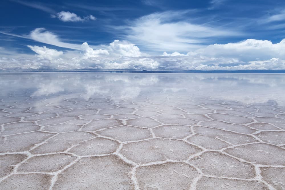
The site offers a rare combination: an expansive salt flat that is perfectly level and transforms into a giant mirror during the rainy season, high-altitude volcanic landscapes, and fauna adapted to extreme conditions (notably Andean pink flamingos). National Geographic describes it as "one of the most extreme and most remarkable views in all of South America, if not on Earth."
Its prominence has been solidified by several media appearances: a stage of the Dakar Rally 2014, filming for the Pékin Express, scenes from the Star Wars saga. Beyond tourism, the salt flat contains lithium reserves estimated at 5.5 million tonnes, making it a major economic issue for Bolivia.
A dried-up sea at 3,658 m altitude
Salar d'Uyuni is the result of the gradual drying of a prehistoric lake. Evaporation left behind a crust of crystallized salt that reaches 10 m thickness in some places. Beneath this layer lies a brine rich in lithium, potassium and magnesium.
The islands that emerge from the salt flat, such as Incahuasi, are actually the peaks of ancient volcanoes submerged by the vanished lake. They are home to giant century-old cacti and offer an elevated viewpoint over the white expanse.
What to see on site
Incahuasi Island
Located at the center of the salt flat, this rocky formation covered with giant cacti (some exceeding 9 m) serves as a standard stop on circuits. A trail allows you to walk around it and reach the summit for a 360° view.
Nearby sites
- Ojos de Sal: saltwater holes that pierce the crust and reveal the underground brine.
- 2014 Dakar Rally Monument: a salt sculpture commemorating the race's passage.
- Train Cemetery: on the outskirts of Uyuni, abandoned 19th-century steam locomotives.
- Salt Museum: a building and furniture entirely carved from salt blocks.
Fauna and photography
Fauna is limited but visible: pink flamingos in peripheral lagoons, vicuñas and viscachas on the heights. The salt flat is also known for perspective photography: the uniform surface and lack of reference points allow playful compositions with accessories (figurines, everyday objects). Consider bringing a few items if this type of shot interests you.
When to go
The salt flat experiences two seasons with opposite atmospheres:
- Rainy season (December to April): a thin layer of water covers the salt crust and creates the characteristic mirror effect. December-January rains can, however, make certain tracks impassable and lead to tour cancellations.
- Dry season (May to November): the ground hardens, all sites are accessible, including Incahuasi Island. The sky is clear and nights are cold.
Peak season runs from June to August, with higher rates and accommodations filling quickly. April-May and September-October offer a good compromise between practical conditions and moderate crowds.
How to get there from Chili
Three main gateways lead to Salar d'Uyuni:
- From Chili (San Pedro de Atacama): local agencies organize 3-day / 2-night circuits that cross the Bolivian border and traverse the Altiplano before reaching Uyuni. To reach San Pedro from Santiago, allow approximately 23 hours by bus, or take a flight to Calama airport, about an hour's drive away.
- From Bolivia: excursions depart from the town of Uyuni, on the immediate edge of the salt flat. A single-day option is possible.
- From Argentina: the Bolivian town of Tupiza serves as a departure base, with circuits reaching Uyuni in 3 to 4 days.
Practical information
The salt flat's average altitude (3,658 m) and that of passes crossed (up to 5,000 m) expose you to mountain sickness. Prior acclimatization in San Pedro de Atacama (2,400 m) or La Paz is recommended. Plan for warm clothing (negative temperatures at night), sunglasses are essential (glare), high-protection sunscreen, and plenty of water.
Accommodations on circuits are basic (shelters, rustic salt hotels), mostly without central heating. The Chili-Bolivian border crossing requires a valid passport; some nationalities require a visa for Bolivia.
Nearby
3-day circuits include the main Bolivian Altiplano sites:
- Laguna Verde: turquoise lagoon at the foot of Licancabur volcano.
- Polques hot springs: natural pools at 4,400 m.
- Sol de Mañana Geysers: active geothermal field at 4,850 m.
- Laguna Colorada: red lake populated by Andean flamingos.
On the Chili side, several sites complement an itinerary: the Salar de Atacama and its lagoons, Lauca National Park in the northern Andes, and Polloquere hot springs for a more intimate stop.
Frequently asked questions
Frequently asked questions
Plan your itinerary
Salar d'Uyuni fits naturally into a journey combining northern Chili and the Bolivian Altiplano. To build a custom circuit including San Pedro de Atacama and the crossing to Uyuni, consult our Chili travel page.
Interested in this visit?
We can include it in your personalised itinerary.